Spatio-Temporal Socio-Technical Risk Analysis
Catastrophic events have made it clear that integrating physical and social causes of failure into a cohesive modeling framework is critical in order to prevent the undesirable consequences of large-scale complex technological accidents. This on-going research develops (1) a theoretical socio-technical causal framework to explicitly incorporate underlying failure mechanisms into Emergency Response (ER) modeling, (2) a methodological technique to create a Spatio-Temporal Socio-Technical Risk Analysis (ST-SoTeRiA) in order to operationalize and quantify the theoretical framework, and (3) a multi-faceted decision making methodology to utilize ST-SoTeRiA for risk-informed ER applications. This research is the first to explicitly incorporate spatial dimensions into socio-technical risk analysis, while being connected with Probabilistic Risk Assessment (PRA) logic. The results of this research will be helpful in protecting public health and safety if a severe Nuclear Power Plant accident leading to a large radiological release should occur.
Level 3 Probabilistic Risk Assessment
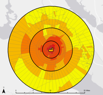
Explicit incorporation of social and organizational factors into Level 1 Probabilistic Risk Assessment (PRA) has been improved theoretically and methodologically and is now in the development stage for application at Nuclear Power Plants (NPPs). The goal of this research is to initiate a similar paradigm for Level 3 PRA. Explicit incorporation of location-specific social factors into Level 3 PRA can drastically affect decisions related to emergency planning, preparedness, and response. The population’s response to a radiological accident, e.g., the 2011 Fukushima Daiichi NPP, demonstrated that understanding the social makeup of the population in the vicinity of NPPs can give policy makers valuable information regarding the effects of their decisions. This research presents a first-time approach for combining a nuclear accident consequence code, MACCS2, with the Social Vulnerability Index utilizing Geographic Information Systems to explicitly consider social factors of the local population in risk models for severe NPP accidents.